 |
|||||||||||||||||||||||
|
The federal electorate of Fremantle in Western Australia is one of 36 Australian House of Representatives electoral divisions which have been contested in every federal election from and including 1901. 14 of these electorates are in New South Wales, 11 in Victoria, 7 in Queensland and 4 (out of an original total of 5) in Western Australia. South Australia and Tasmania did not have separate electoral divisions until the 1903 election. Fremantle is also significant in that John Curtin, who held the seat between 1928 and 1931 and from 1934 until his death in 1945, is still the only Australian Prime Minister to represent a Western Australian seat in the Parliament. In the sixty one years since Curtin's death there have been only three members for Fremantle, all representing the Australian Labor party and all attaining ministerial rank. The members of the First Parliament of the Commonwealth of Australia were elected on 29 and 30 March 1901. 36 members were elected to the Senate with 6 from each State. In the House of Representatives 75 members were elected with representation as follows - New South Wales 26, Victoria 23, Queensland 9, South Australia 7 and Western Australia and Tasmania each 5, the minimum number guaranteed to each Original State under Section 24 of the Constitution. The Western Australian representation remained at 5 until the 1948 redistribution when the State received 8 members (its proportional entitlement) in the expanded House of 121 members and 10 Senators of the 60 in the revamped upper House. By the beginning of 2006 there were 76 members of the Senate and 150 members of the House of Representatives with Western Australia having 15 members in the House at a time when the State had approximately 10% of the total national population. |
|||||||||||||||||||||||
|
JCPML. Records of John Dawkins. Group photograph of Members in House of Representatives, c 1980. JCPML00161/365 |
|||||||||||||||||||||||
|
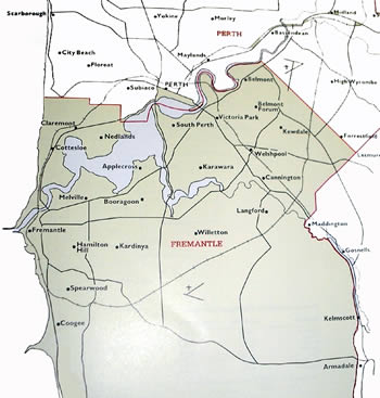
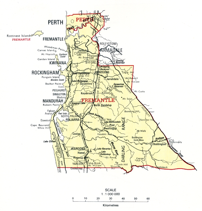
In both South Australia and Tasmania the original members in 1901 were elected from a contest in which the whole State was polled as one division. In Western Australia, by contrast, the State Parliament legislated for the boundaries of the five divisions - Perth (enrolment 18,482), Fremantle (16,759), Swan (19,024), Coolgardie (15,969) and Kalgoorlie (18,811). In moving the second reading of the Federal House of Representatives WA Electorates Bill on 13 September 1900, the Premier Sir John Forrest pointed out that while it was not 'obligatory' for the State to be divided into five electorates 1 'there is not', he contended, 'the slightest doubt that the spirit of the Federal Constitution requires that the House of Representatives shall represent divisions of the colony'. In making the proposed distribution Forrest explained that the basis for his determination had been (a) the respective populations of the proposed divisions and (b) the number of voters who voted at the federation referendum in July 1900. In broad terms the distribution Forrest foreshadowed provided for two metropolitan electorates (Perth and Fremantle), two representing 'the goldfields interest' (Kalgoorlie and Coolgardie) and one for the agricultural and pastoral interest (Occident). With some changes, including the renaming of Occident as Swan, the distribution was adopted by the Parliament. As already indicated four of the original five divisions have survived for the whole of the 105 years since federation, with only Coolgardie disappearing. Unsurprisingly, however, each of the districts bearing an original 1901 name has now a very different geographical extent from its original boundaries. In this study the focus will be on the seat of Fremantle where suburbs adjacent to the port city now form a much more substantial part of the electorate than was the case in the first half of the twentieth century. Initial boundaries - 1901 & 1903 electionsThe initial boundaries for Fremantle were used in the 1901 and 1903 elections. As can be seen from Map 1A, the Fremantle division included North Fremantle, Cottesloe, Claremont and Nedlands on the northern side of the Swan River. South of the river, the electorate extended eastwards from Fremantle through Melville, South Perth and Victoria Park to Belmont; then southwards through Kewdale, Cannington, Gosnells and Kelmscott to Armadale and westwards to Coogee; and from there along the ocean through Spearwood and Hamilton Hill. As Map 1B shows, the division also took in country areas to the south and east including Rockingham, Mandurah, Lake Clifton, Pinjarra, Dwellingup, Waroona (formerly known as Drakesbrook), Yarloop, Mundijong, Jarrahdale and present day Boddington. |
|||||||||||||||||||||||
|
|
|||||||||||||||||||||||
|
Maps 1A and 1B: The federal electorate of Fremantle from 1901-1905. JCPML. Records of the John Curtin Prime Ministerial Library. Fremantle electorate map, 1901-1905. JCPML00968/1/1. Reproduced from Commonwealth of Australia. 1901-1988 electoral redistributions. Canberra, 1989. Courtesy of Geoscience Australia. |
|||||||||||||||||||||||
|
1. WAPD 13 September 1900. Section 29 of the Constitution provided that 'until the Parliament of the Commonwealth otherwise provides the Parliament of any State may make laws for determining the divisions in each State for which members of the House of Representatives may be chosen ...' and that 'In the absence of other provision each State shall be one electorate'. Back |
|||||||||||||||||||||||
|
|||||||||||||||||||||||
|
|||||||||||||||||||||||
m.jpg)
