1968 redistribution - 1969 & 1972 elections
1974 part redistribution - 1974 & 1975 elections
On 21 November 1968 a redistribution was proclaimed affecting all States except Queensland and this applied for the 1969 and 1972 elections.
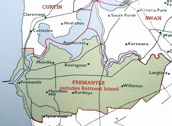
The Fremantle electorate (see Map 8) on the south side of the river moved further east taking in Cannington, Willetton and neighbouring areas but lost Cottesloe to the Curtin electorate. The subdivisions now included Applecross, Ardross, Coolbellup, Hamilton Hill, Melville, Palmyra and Riverton as well as Fremantle and South Fremantle.
In a further part redistribution on 19 April 1974 affecting New South Wales and Western Australia and applying to the 1974 and 1975 elections, Western Australia received an additional tenth seat (Tangney4 ) with the Fremantle enrolment of 62,636 placing it about 9% above the State's mean quota.
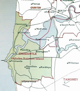
The creation of the metropolitan seat of Tangney, located south of the river and including Willetton, Cannington and Gosnells, led to Fremantle's eastern boundary south of the river moving back to a little east of Kardinya (see Map 9). The subdivisions of Applecross, Ardross and Riverton were no longer within the Fremantle electorate, being replaced by reincorporated subdivisions, Claremont and Cottesloe. |

|
Map 8: The federal electorate of Fremantle from 1968-1974.
JCPML. Records of the John Curtin Prime Ministerial Library. Fremantle electorate map, 1968. JCPML00968/1/8.
Reproduced from Commonwealth of Australia. 1901-1988 electoral redistributions. Canberra, 1989. Courtesy of Geoscience Australia. |

|
Map 9: The federal electorate of Fremantle from 1974-1977.
John Curtin Prime Ministerial Library. Records of the JCPML. Fremantle electorate map, 1974. JCPML00968/1/9
Reproduced from Commonwealth of Australia. 1901-1988 electoral redistributions. Canberra, 1989. Courtesy of Geoscience Australia. |
1977 redistribution - 1977 elections
1980 part redistribution - 1980 & 1983 elections
The next redistribution was proclaimed on 7 November 1977 and was used for the 1977, 1980 and 1983 elections except in Western Australia where a second redistribution was proclaimed on 26 February 1980 and used for the 1980 and 1983 elections. Under this latter distribution the State received an eleventh seat, O'Connor, taking in most of the wheatbelt south of Morawa and east of Perth and the coastal electorates of Moore and Forrest.
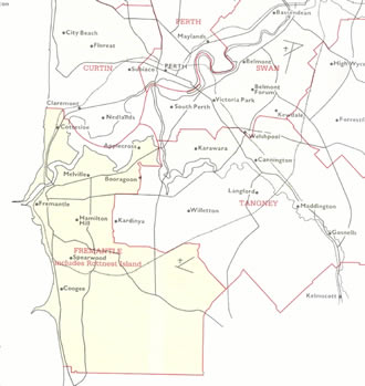
The boundaries which applied for Fremantle in 1977 (see Map 10) saw the western boundary move south of Coogee while on the eastern boundary the area around Kardinya was moved into Tangney and Claremont returned to the Curtin electorate. The subdivisions were Applecross, Cockburn, Coolbellup, Cottesloe, Fremantle, Melville, Palmyra and South Fremantle.
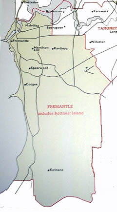
The 1980 changes (see Map 11) saw the south western section of the division move further south again to take in Kwinana, while the eastern boundary south of Booragoon moved again towards Willetton, in the process reincorporating Kardinya, while all of Claremont and Cottesloe were removed leaving North Fremantle from this time on as the only area in the division north of the Swan River. The 1980 and 1983 subdivisions included Fremantle, Bull Creek, Cockburn, Coolbellup, Kwinana and Palmyra. |

|
Map 10: The federal electorate of Fremantle 1977-1979.
John Curtin Prime Ministerial Library. Records of the JCPML. Fremantle electorate map, 1977. JCPML00968/1/10.
Reproduced from Commonwealth of Australia. 1901-1988 electoral redistributions. Canberra, 1989. Courtesy of Geoscience Australia. |
|
Map 11: The federal electorate of Fremantle 1980-1983.
John Curtin Prime Ministerial Library. Records of the JCPML. Fremantle electorate map, 1980. JCPML00968/1/11.
Reproduced from Commonwealth of Australia. 1901-1988 electoral redistributions. Canberra, 1989. Courtesy of Geoscience Australia. |


