A central and unique feature of the Parry Endeavour's journey was that the yacht carried an ocean science package to enable scientific measurements to be made during the two years of the voyage. The equipment was designed to be reliable, safe and easy for Jon Sanders to use. 7
The research undertaken related to the objectives of the voyages made by Captain James Cook from 1768. A key aim of the Parry Endeavour's journey was to complete scientific research as Cook had, and to emulate his navigational achievements.
Consequently, Sanders' triple circumnavigation of the world was recognised as an official Australian Bicentenary Activity by the Australian Bicentennial Authority.
There are some interesting parallels in the lives of James Cook and Jon Sanders. Both men received recognition as navigators. Also, in the mid-18th century the Sanders family were based in Whitby, where Cook began his maritime career. 8
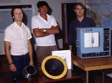
The scientific package on board the Parry Endeavour was designed by John Penrose, Director of Curtin's Centre for Marine Science and Technology (CMST), with advice and support from other scientific bodies in Australia, Great Britain and the United States. The package had three elements: sea surface temperature measurements (SSTs), wildlife sightings and bathymetric measurements. 9

Records of Project Endeavour.
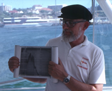
John Penrose showing sounder charts
to Project Endeavour members, 1987.
CUL00039/15/22.
Sea Surface Temperature Measurements (SSTs)
There is a worldwide database of SSTs measured by surface vessels and scientists compare this data to measurements taken with satellite instruments. The sea surface temperature information assists in understanding the world's climate. As very few surface vessels travel the Southern Ocean routes chosen by Sanders, these measurements were a valuable contribution to the worldwide database. 10
Wildlife Sightings
Sanders was asked to maintain a log of wildlife sightings, particularly sightings of whales and dolphins. The Parry Endeavour was equipped with hydrophones so that Sanders could record whale sounds. 11
Sanders also illustrated his logbooks with sketches he made of wildlife spotted during the journey. 12
Bathymetric Measurements
Bathymetric measurements record sea depth. This feature of the science package in particular tied the voyage to Cook's goal to locate Terra Australis in his exploratory voyages in the Southern Pacific.
Ocean surveys sketch in the broad bathymetry of the Southern Pacific Basin but these surveyed areas are widely spaced, meaning that true depth information is sparsely distributed. Even though these surveys discredit the idea of a great Southern land mass, the possibility remains that substantial sea bed structures are yet to be discovered. 13
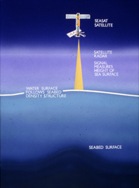
In 1978, the NASA satellite SEASAT was equipped with an altimeter for measuring sea surface elevation. SEASAT's altimeter readings allowed potential bathymetric anomalies, such as possible seamounts, to be identified.
Generally SEASAT surface elevation predictions and existing bathymetric surveys correlate well but there was a divergence located in the South Pacific centred at 41°S, 152°W. The SEASAT predictions revealed a region of approximately 2° latitude and 5° longitude which had an unexpected mound of up to one metre above the local average.The General Bathymetric Chart of the Oceans (GEBCO) indicated a depth of 5,000-5,100 metres in the area, but SEASAT predicted that the depth could be 1,000-2,000 metres lower than the GEBCO chart suggested.
The full records of SEASAT and bathymetric data are held at CMST and the Jet Propulsion Laboratory (JPL) in Pasadena, California. Dr Parke from the JPL acted as a scientific consultant for the voyage. 14
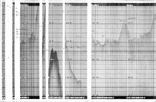
The plan was for Sanders to check the depth features in the area of interest in the South Pacific and confirm the existence or otherwise of a sea mount in the region. By equipping the yacht with a Raytheon depth sounder capable of recording up to 6km, the accuracy of the SEASAT satellite data could be assessed by CMST.
Sanders sailed the yacht over the specific areas indicated by CMST with the express purpose of investigating the depth anomalies. 15
 |
|||||||||||


