 |
||||||||||||||||||||||||
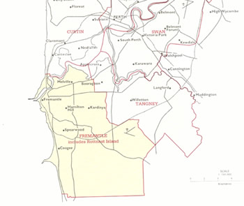
1984 redistribution - 1984 & 1987 electionsA redistribution dated 31 August 1984 was used for the 1984 and 1987 elections. Western Australia now had thirteen seats including the new seats of Cowan in the northern suburbs and Brand stretching south from Kwinana. The main effect of the changes on Fremantle (see Map 12) was the excision of the Kwinana area. Statistics linked to subdivisions were replaced by statistics linked to polling places from the 1984 election, with the largest polling places in the division including Hamilton Hill and Hamilton Hill East, Attadale, Spearwood, Bicton, Myaree, Fremantle, Coolbellup East, Hilton Park, Palmyra, Plympton and Kardinya. |
||||||||||||||||||||||||
Map 12: The federal electorate of Fremantle from 1984-1988. JCPML. Records of the John Curtin Prime Ministerial Library. Fremantle electorate map, 1984. JCPML00968/1/12. |
||||||||||||||||||||||||
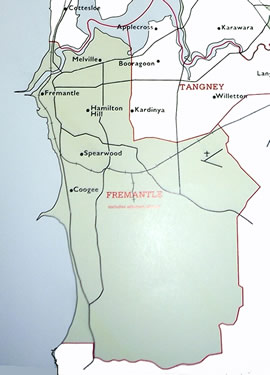
1989 redistribution - 1990, 1993 & 1996 electionsThe redistribution of 31 March 1989 was used for the elections in 1990, 1993 and 1996. A fourteenth seat, Pearce, surrounding Perth to the east, northeast and south east, was included. The changes to Fremantle were relatively minor (see Map 13). Additions to polling places in 1990 compared with 1984 included Bibra Lake, East Fremantle, Samson, South Lake and Hamilton Hill North and south, while Booragoon was removed from the list. |
||||||||||||||||||||||||
Map 13: The federal electorate of Fremantle 1989-1997. JCPML. Records of the John Curtin Prime Ministerial Library. Fremantle electorate map, 1989. JCPML00968/1/13. |
||||||||||||||||||||||||
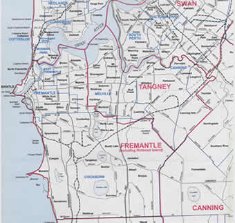
1997 redistribution - 1998 electionNo further redistribution occurred until 6 March 1997 and the new slightly modified Fremantle boundaries (see Map 14) were used for only one election namely in 1998. The boundary of the electorate ran southwards from Fremantle to south of Henderson and Wattleup then north and northeast taking in Banjup, Atwell and Jandakot. The boundary then continued westward taking in North Lake and Coolbellup before heading north to the Swan River east of Attadale and then back to Fremantle including North Fremantle. New polling places were included at Atwell and Lakeland. |
||||||||||||||||||||||||
Map 14: The federal electorate of Fremantle 1997-1999. JCPML. Records of the John Curtin Prime Ministerial Library. Australian Electoral Commission. Fremantle electorate map, redistribution 1997. JCPML01087/1. |
||||||||||||||||||||||||
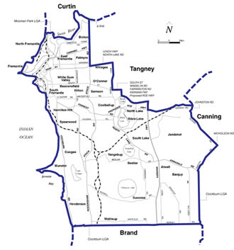
2000 redistribution - 2001 & 2004 electionsThe most recent redistribution dating from 20 November 2000 saw Western Australia receive a fifteenth seat, Hasluck, in the eastern metropolitan area, bringing to five - Forrest, Curtin, Tangney, Pearce and Hasluck - the number of federal divisions in the West named after federal politicians: Two State politicians - David Brand and Edith Cowan - have also been recognized in this way. In its present form the western boundary of Fremantle runs southwards along the coast from North Fremantle south of Coogee to Henderson. The southern boundary then extends eastwards past Wattleup to south of Banjup and Atwell and the eastern boundary runs north to Leeming Road incorporating Jandakot. The winding north boundary extends to the west past North Lake and Bibra Lake, turns northwards to take in Willagee and then north again incorporating Palmyra and Bicton before following the Swan River to North Fremantle. |
||||||||||||||||||||||||
Map 15: The federal electorate of Fremantle 2000. JCPML. Records of the John Curtin Prime Ministerial Library. Australian Electoral Commission. Fremantle electorate map, redistribution 2000. JCPML01087/2. |
||||||||||||||||||||||||
When the electors went to the polls in 2004 there were 1,248,632 enrolled voters in Western Australia compared with 89045 in 1901. The average enrolment across the fifteen Western Australian electorates was 83,242 with the highest enrolment in Forrest (87,145) and the lowest in Moore (75,823). Fremantle with 83698 enrolled electors was marginally above the mean. In the four contested seats in 1901 the average turnout was only 36.64% with Fremantle registering below average with 31.11% of enrolled voters receiving ballot papers. By contrast in 2004 the average turnout (with compulsory voting) was 92.80% with the Fremantle figure a little above average at 93.20%. |
||||||||||||||||||||||||